Chongqing read the vertical city in section
In Chongqing, a point that appears next door can sit several levels, escalators or road loops away. The Jialing and Yangtze rivers, steep peninsula and elevated transit turn altitude into ordinary navigation. Read the city in section—upper street, lower bank, bridge and station exit—before chasing night views or distant karst.
Replace the flat map with an elevation stack
The eight chapters move from Yuzhong’s ridge to lower riverbanks, across transit lines and finally out to protected heritage. Every descent creates a future ascent, so each route includes its return.
Jiefangbei and the upper peninsula
Use Jiefangbei as an orientation point, not as the whole center. Walk one ridge-level street sequence, note which entrances descend toward the rivers and keep the hotel return on the same elevation whenever a late meal follows.
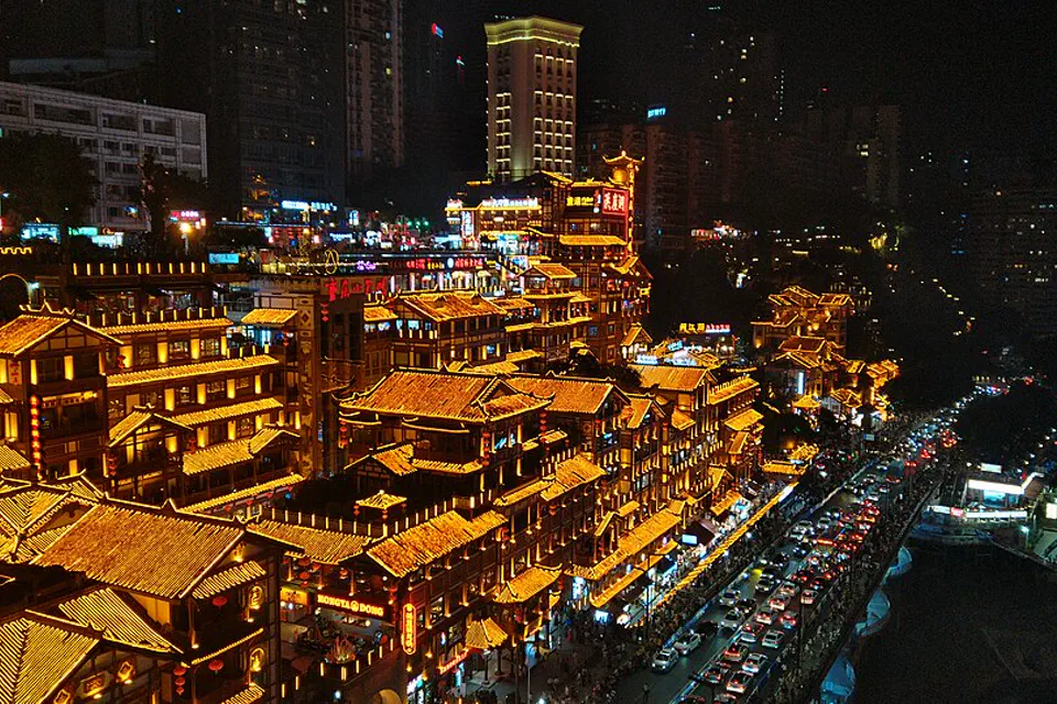
Hongya Cave from outside first
The complex is most legible as a vertical circulation and riverfront phenomenon. View it from a safe public position, expect intense night crowds and do not assume the entrance nearest a map pin leads to the level shown in photographs.
Yangtze River Cableway as transport theater
The cableway can have long queues and weather-related changes. Compare the wait with a metro or bridge crossing, verify the boarding side and treat the ride as optional rather than sacrificing a full afternoon to a few minutes in the air.
Liziba and rail without blocking daily life
The train-through-building view is part of a functioning neighborhood and transit system. Use the designated viewing area, keep sidewalks and station movement clear and combine it with one nearby route rather than arriving solely for repeated video takes.
Chaotianmen and the confluence
Construction, cruise terminals and public-space access can change around the river meeting. Verify the usable viewpoint and pier, keep the steep return in mind and avoid describing a shopping complex as if it were the historic port itself.
Hotpot with a safe trip uphill
Choose the restaurant by broth options, ingredient clarity and return transport, not by how many stairs appear in a viral approach video. Shared pots complicate allergies, and late queues can end after convenient transit has thinned.
Dazu Rock Carvings as a dedicated heritage day
The carved sites lie outside central Chongqing and need exact transport and site selection. Use official heritage context, respect conservation barriers and avoid compressing Dazu into the same day as a Wulong or city-night plan.
Wulong is a separate terrain system
Wulong’s natural bridges, caves and resort areas sit far from the urban core. Confirm station, park shuttle, steps and weather; an overnight can be more honest than a city-to-park sprint with no buffer.
Make three decisions while the map is still quiet
Chongqing North, West and Shapingba differ
Major rail stations serve different corridors and city edges. Match the exact station to the hotel and first-day elevation, and preserve extra time for large internal walks and an unfamiliar exit.
A ridge-level metro base reduces daily climbs
Yuzhong offers iconic density but hotels on lower roads or steep lanes can be awkward with luggage. Jiangbei and Shapingba suit different plans. Confirm the door’s elevation and accessible route, not only its distance from a station pin.
Choose Dazu or Wulong, not both at speed
Dazu is a cultural heritage day; Wulong is a terrain and weather day. On a short stay, select the one that fits the trip’s argument and leave the other for a return.
A route that always knows how it gets back up
Use one ridge day, one river-and-transit day, one slower neighborhood day and one optional outer chapter. Night views should finish a coherent route rather than start an improvised climb.
Jiefangbei to one river edge
Learn Yuzhong at upper-street level, descend once for a confluence or Hongya perspective and return by a known metro, escalator or road chain.
Transit as urban section
Use rail and one bridge or cableway to understand the city’s vertical mechanics. Keep Liziba or another viewpoint brief and spend time in the connected neighborhood.
Museum, food and a quiet bank
Choose one institution or historical district, then one hotpot or noodle focus. Stay near the same transit corridor for the evening rather than collecting distant neon scenes.
Dazu or Wulong
Commit to one landscape with the correct station, shuttle and entry known. Keep the city alternative ready when weather or ticket availability undermines the outer plan.
Elevation is the hidden fare
One wrong exit can add a hill
Record the metro exit and whether it opens above or below the destination. When accessibility matters, verify elevators and road approaches rather than relying on a staircase-heavy walking route.
Visibility changes the night-view value
Mist and rain can erase skyline depth and make steps slick. Keep night viewpoints optional, protect a museum or food route and never cross barriers for a clearer angle.
Rail arrival is not park arrival
Wulong and Dazu still require local transfers after intercity movement. Name the exact scenic component, shuttle and final departure before committing to a same-day return.
Chongqing planning FAQ
How many days should I spend in Chongqing?
Three full days cover the central vertical city, one river-and-transit route and slower cultural or food depth. Add a fourth or fifth for Dazu or Wulong without sacrificing the city.
Is Hongya Cave a traditional ancient complex?
The site is a modern commercial complex drawing on stilt-house forms. It is useful for understanding contemporary night tourism and vertical circulation, but should not be presented as untouched ancient fabric.
Can I visit Wulong as a day trip?
A day trip is possible with an early, precisely coordinated train or driver and a limited park plan. An overnight is more resilient when weather, shuttles or walking time are important.
Where should I stay for a first Chongqing visit?
A metro-accessible ridge-level base in or near central Yuzhong is practical for iconic routes, provided the hotel entrance is not hidden down steep lanes. Check the actual door and elevator route.
Official sources and photo credit
Planning facts and licenses were reviewed on 28 August 2026. Transport, reservations, protected-area access, border rules and local operating arrangements change; verify the current authority or operator close to travel. The image was resized and converted to WebP; its display crop may vary by screen, with no other material changes.