Zhangjiajie use a pillar-and-gate fieldbook
“Zhangjiajie” can mean the prefecture-level city, the urban gateway, Wulingyuan District, the national forest park or a broader scenic network. Those names are not interchangeable when buying tickets or choosing a hotel. Start with the correct gate and shuttle system, then let fog, stairs and cliff comfort determine how much terrain belongs in one day.
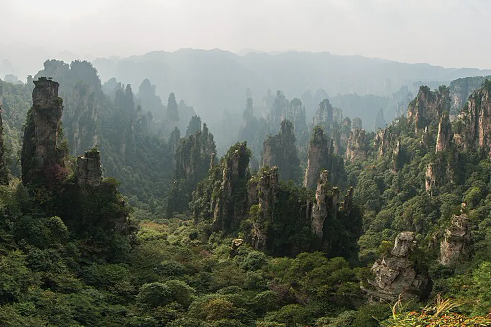
Map the park vertically before tracing it horizontally
Valley walks, elevator or cableway access, upper plateaus and city-based Tianmen Mountain create separate operating systems. These chapters keep each gate, queue and descent attached to its actual day.
Wulingyuan or Zhangjiajie city
Wulingyuan places travelers near major park access, while the urban center suits rail, airport and Tianmen Mountain. A single hotel does not minimize both. Choose the base by two consecutive mornings and name the exact entrance in every driver request.
Golden Whip Stream as a ground profile
The valley route offers forest and pillar scale without beginning at a high cliff edge. Check current open sections and shuttle links, avoid feeding macaques and keep food secure; a quiet lower walk can be more rewarding than rushing to every upper platform.
Bailong and Yuanjiajie queue logic
The elevator creates a rapid elevation change but can concentrate demand. Verify ticket relationship, choose ascent or descent strategically and keep an alternative route when wait time would consume the planned plateau walk.
Yuanjiajie beyond one named pillar
Viewpoints are connected by shuttles and crowded paths rather than one empty ridge. Use official maps, accept fog and focus on landform scale; fictional movie associations should not replace geological or conservation context.
Cableway, shuttle and descent in one chain
Tianzi Mountain can connect high viewpoints with different descent options. Check the final shuttle and cableway operation, avoid committing to steep stairs late and keep the same gate return visible if luggage waits elsewhere.
Yangjiajie only when access supports it
Trail openings, maintenance and steep sections can change. Use current park notices, select routes appropriate to mobility and weather and do not enter closed branches because older blogs call them crowd-free.
Tianmen Mountain is not inside Wulingyuan
The urban cableway and mountain road form their own ticketed day with glass walks, stairs and weather exposure. Confirm the route type and boarding point, and never combine it casually with a full national park itinerary.
Yellow Dragon Cave as a weather alternative
A managed cave can offer geological contrast, but stairs, lighting and group flow matter. Verify current operation and use it as a deliberate chapter, not as a promise that every rainy day has a frictionless indoor replacement.
Make three decisions while the map is still quiet
West station, airport and park town are separate
Rail arrivals may use Zhangjiajie West, while Wulingyuan accommodation sits farther by road. Confirm the late-arrival connection and do not label a park-town hotel as “beside Zhangjiajie station.”
Split city and Wulingyuan on longer stays
Stay in Wulingyuan for repeated park gates and in the city for Tianmen or early transport. A split stay costs packing time but can prevent two long road commutes.
Choose the day by cliff comfort
Glass paths, exposed viewpoints, cableways and long stairs affect travelers differently. Build a lower-valley alternative and never pressure a companion into a height route because the ticket is prepaid.
A park plan with a known ascent and descent
Use two Wulingyuan days, one flexible contrast and one separate Tianmen day. Fog is a condition to work with, not a cue to cross closed barriers.
Golden Whip Stream and ground scale
Enter through the selected gate, keep the lower walk coherent and learn the shuttle system before attempting a complex upper-plateau connection.
One elevator or cableway circuit
Choose Yuanjiajie or Tianzi as the main upper profile, monitor queues and return through the planned gate without improvising a late stair descent.
Second branch or cave
Use visibility and access notices to select a quieter open branch, cave or recovery day. Preserve legs and time for the separate city mountain.
Urban cableway mountain
Start from the correct city boarding point, follow the booked route and keep weather, glass-walk comfort and the final descent system aligned.
The gate printed on the ticket controls the day
Use the current official park map
Old route diagrams may omit closures or changed shuttles. Save the current entrance and last transport, then confirm major changes with staff before leaving the gate area.
Do not feed or confront macaques
Keep food and loose items secured, maintain distance and follow park guidance. A close photograph is not worth conditioning wildlife to approach people.
Rain changes stone and cliff exposure
Wear shoes with grip, slow down on wet steps and skip exposed routes during unsafe weather. Cableways and outdoor attractions can suspend operation even when the city remains dry.
Zhangjiajie planning FAQ
Is Zhangjiajie National Forest Park the same as Tianmen Mountain?
No. The forest park is part of the Wulingyuan scenic system outside the urban core; Tianmen Mountain uses a separate city-based ticket and transport system.
Where should I stay for Wulingyuan?
Wulingyuan town is practical for repeated park days. Stay in Zhangjiajie city when Tianmen Mountain, airport or rail timing dominates, or split bases on a longer visit.
Can I see Wulingyuan in one day?
One day can cover one lower or upper circuit, but not the whole protected landscape. Two days allow one valley profile and one plateau route with weather flexibility.
What if the park is foggy?
Fog can reveal nearby pillars while hiding long views. Use a lower forest route, cave or cultural alternative, and avoid chasing exposed viewpoints when visibility and surfaces are poor.
Official sources and photo credit
Planning facts and licenses were reviewed on 28 August 2026. Transport, reservations, protected-area access, border rules and local operating arrangements change; verify the current authority or operator close to travel. The image was resized and converted to WebP; its display crop may vary by screen, with no other material changes.